Posts

Showing posts from June, 2021

HOW TO BUILD 3D GEOSPATIAL DATA (LOD0 to LOD1) USING ARCGIS PRO

Image
How to build 3D GIS and Geospatial Data from Level of Detail 0 (polygon) to Level of Detail 1 (extrude model and multipatch) using ortho imagery and digital elevation raster obtained from UAV / Drone Photogrammetric Processing.  

Extract Building Footprints from LIDAR or Photogrammetric Point Clouds Data Using ArcGIS Pro

Image
How to extract building footprints polygon from point clouds data generated from LIDAR or Photogrammetric UAV Survey. If you have LIDAR points clouds, the perfect and precise result is guaranteed. If you are using Point clouds data generated from photogrammetric processing of aerial or UAV Survey, make sure you perform precise point clouds classification first, or else some misclassified and wrongly extracted building footprints are expected. 

Image Segmentation. A Completed Workflow From Training Samples Generation to Accuracy Assessment

Image
Image classification for landcover mapping has so many types of algorithms or methods. One of them is Image Segmentation and Classification. The process can be described as imagery is segmented into many segments, and from there we classify them according to the specified classification schema.  This video tutorial below is about how to perform object-based image segmentation and classification using Satellite Imagery data. Not only the segmentation, but I also made this video as a workflow, which means I demonstrate from the training samples generation (for supervised classification), ground truth creation data to support accuracy assessment, the image segmentation process, and closing with the accuracy assessment to inspect the accuracy of the final classified raster. Almost every step is automatic so it will save a ton of time and effort.  So if you are curious, check this below

ArcGIS Enterprise Orthomaker App

Image
In this tutorial, I will show you a new application from ArcGIS Enterprise/Portal for ArcGIS Family. The application is called Ortho Maker. This app is designed to provide Photogrammetric UAV Photo processing inside ArcGIS  Enterprise/Portal. If you are familiar with DroneDeploy or Pix4D Clouds, this application offers similar features.  Because it is implemented inside ArcGIS Enterprise Environment, you can publish the processing results as ArcGIS API Services, either in tiled static map services or dynamic image services. Previously, ESRI has released Drone2Map as a desktop-based UAV Processing software a few years ago, and UAV photogrammetric processing capabilities also have been implemented in ArcGIS Desktop and ArcGIS Pro. So Ortho Maker is the ESRI answer for Cloud-based UAV Photogrammetric processing needs.  Ortho Maker implementation needs an instance of ArcGIS Image Server (functioned as raster analysis module and raster hosting server). But for optimal performance, ESRI reco

Informasi Dasar Sistem Informasi Geografis / Basic Introduction of Geographic Information System / GIS

Image
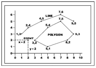
Definisi Sistem Informasi Geografis Sistem Informasi Geografis (Geographic Information System/GIS) yang selanjutnya akan disebut SIG merupakan sistem informasi berbasis komputer yang digunakan untuk mengolah dan menyimpan data atau informasi geografis (Aronoff, 1989). Secara umum pengertian SIG sebagai berikut: ” Suatu komponen yang terdiri dari perangkat keras, perangkat lunak, data geografis dan sumberdaya manusia yang bekerja bersama secara efektif untuk memasukan, menyimpan, memperbaiki, memperbaharui, mengelola, memanipulasi, mengintegrasikan, menganalisa dan menampilkan data dalam suatu informasi berbasis geografis ”. Data Spasial Sebagian besar data yang akan ditangani dalam SIG merupakan data spasial yaitu sebuah data yang berorientasi geografis, memiliki sistem koordinat tertentu sebagai dasar referensinya dan mempunyai dua bagian penting yang membuatnya berbeda dari data lain, yaitu informasi lokasi (spasial) dan informasi deskriptif (attribute) yang dijelaskan berikut ini :