Posts

Showing posts with the label dtm

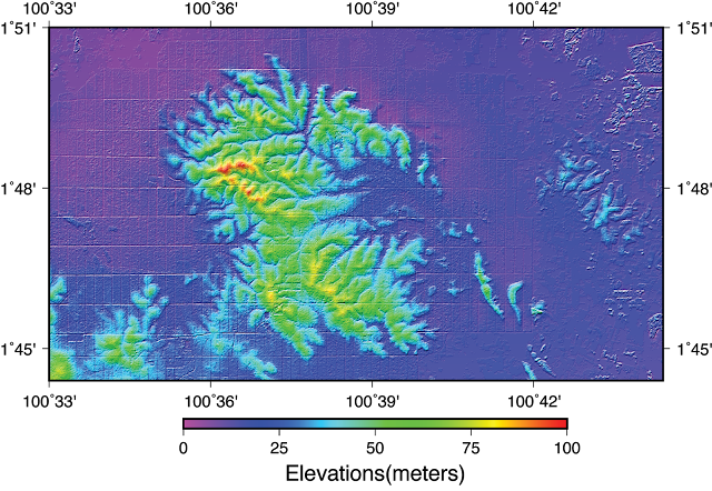
Extract DEM from Stereo Satellite Imagery Using Agisoft Metashape

Image
Agisoft Metashape (formerly Agisoft Photoscan) is a well known Photogrammetric UAV/Drone Processing software. Using this software you can make DEM, DSM, DTM, orthophotos, orthomosaics, and 3D model from Drone / UAV survey. In the latest version, this software expanded its capabilities not only enable to process UAV/Drone Photos, but also Stereo / Tri Stereo Satellite Imagery. This feature is awesome because existing Stereo Satellite imagery processing is only can be facilitated by expensive remote sensing software like ERDAS IMAGINE, ENVI, PCI Geomatica, Socet Set. Different with dedicated remote sensing software, Agisoft Metashape can generate DEM without GCPs. Photogrammetry become more simple, altough if we talks about accuracy, that is another problem. Anyway here is my experiment and experience when I am trying the Agisoft Metashape for stereo satellite imagery processing. 

How to download SRTM DEM Directly in QGIS

Image
SRTM DEM is one of the most popular and most widely used Digital Elevation Model (DEM) data at the global level. The DEM itself actually is quite old because it is coming from SAR Survey using Space Shuttle in the year 2000. SRTM DEM generated from interferometric processing of two SAR antennas mounted on the space shuttle and using two bands configuration, one using X-band and the other is using C-band. X-band SAR of SRTM is considered experimental so it is doesn't have full coverage like its counterpart C-band SAR. Because it is coming from SAR interferometry, the resulted DEM is still considered as DSM (Digital Surface Model) and not be treated as DTM (Digital Terrain Model). Although conversion to DTM is somewhat possible (I also have made a tutorial about how to do it in another post), the result is can't be standardized due to its medium resolution. But because there is no on-par DEM data on a global scale at medium resolution like SRTM DEM, the data is still found popula...

Data Digital Elevation Model Nasional (DEMNAS) dan Batimetri Nasional dirilis

Image
Pemerintah Republik Indonesia melalui Badan Informasi Geospasial (BIG) saat ini telah menyelesaikan dan merilis produk data Digital Elevation Model (DEM) nasional untuk seluruh wilayah Indonesia pada resolusi 0.27 arcsecond. Data dapat diunduh dari LINK ini. Data ini akan sangat bermanfaat untuk akselerasi kegiatan pemetaan dan peningkatan kualitas dan kuantitas output pemetaan di Indonesia, sekaligus mengurangi gap dan inkonsistensi berbagai data spasial yang sudah dan akan dihasilkan di masa depan (baik tematik maupun geometrik) satu langkah besar menuju Indonesia Maju 2045.

How to make DTM from DSM DEM Processing in QGIS Tutorial

Image
how to make DTM (digital terrain model) from DSM (digital surface model) in QGIS Tutorial. This tutorial is using QGIS Version 3.2 Bonn. Check this out