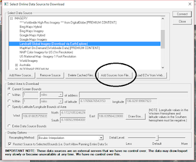
Actually, we could display online map services into global mapper and further leverage the software capabilities to deal with certain tasks. This can be achieved using protocol similar to what we do in SASPlanet, i.e creating an xml file which contain the URL and tags, import it to global mappers's online data sources and just go mapping. Start by copy the code below in an XML file <source_list creator= "Global Mapper - http://www.globalmapper.com" version= "1.0" xmlns:xsi= "http://www.w3.org/2001/XMLSchema-instance" xmlns= "http://www.globalmapper.com/OSL/1/0" xsi:schemalocation= "http://www.globalmapper.com/OSL/1/0 http://www.globalmapper.com/OSL/1/0/gmc.xsd" > <source type= "GMAP" ></source> <name> Bing Maps Hybrid </name> <group_list> <group> <![CDATA[*** POPULAR SOURCES ***]]> </group> <group> IMAGERY ...